![]()
SPOT 5's instruments and ground processing systems deliver imagery with significantly better resolution and quality than previous SPOT satellites.
| Satellite |
SPOT 1-4
|
SPOT 5
|
||||||
| Instrument |
HRV/ HRVIR
|
HRG
|
HRS | |||||
| Spectral band | PAN | B1, B2, B3 | SWIR | VHR | PN | B1, B2, B3 | SWIR | PAN |
| Swath | 60 km | 60 km | 60 km | 60 km | 60 km | 60 km | 60 km | 120 km |
| Resolution | 10 m | 20 m | 20 m | 2.5 m | 5 m | 10 m | 20 m | 5 m * 10 m |
| Absolute location accuracy (without ground control points) | 350 m | 350 m | 350 m | 50 m | 50 m | 50 m | 50 m | 20 m |
| Geometric accuracy | 5 m | 5 m | 5 m | < 3 m | < 3 m | < 3 m | < 3 m | < 3 m |
| Signal-to-noise ratio (L2) | 260 | 380 | 360 | 170 | 170 | 240 | 230 | 190 |
| MTF (fn/2) | 0.3 | 0.45 | 0.35 | 0.2 | 0.3 | 0.4 | 0.45 | 0.3 |
SPOT 1-4 and SPOT 5 main technical data
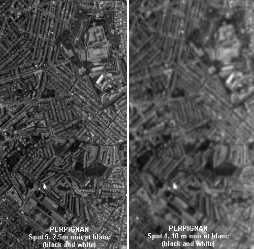
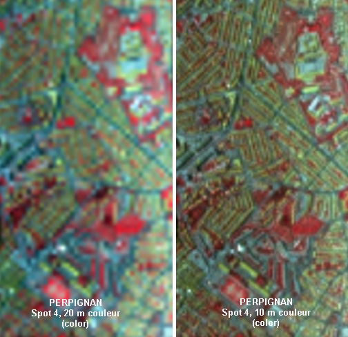
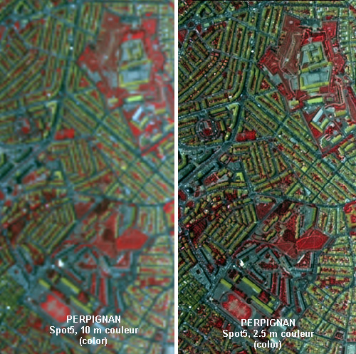
The real SPOT 4 and simulated SPOT 5 images shown here illustrate the advances made with the new HRG instruments and Supermode sampling concept:
Comparison of SPOT 4/5 imagery of Perpignan, France:
More examples
Spot 5,
Perpignan (other district) - 248 ko
Comparison Spot 4/5,imagery of Nice, France-
256 ko
Comparison Spot 4/5,imagery
of Toulouse, France- 135 ko
VEGETATION
images of the globe