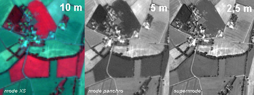
SPOT 5 Supermode
Supermode is a unique image sampling process that offers
significantly improved resolution in the panchromatic band without major
modifications to the satellite, thanks to sophisticated processing operations
on the ground.
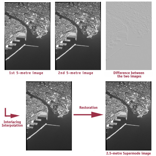
The Supermode process generates a single image at a resolution of 2.5
metres from two panchromatic images acquired simultaneously at a resolution
of 5 metres and offset vertically and horizontally by 2.5 metres.
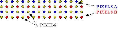
Onboard processing
Imagery is acquired by two dedicated arrays of CCD detectors offset
in the focal plane. The instrument thus generates two 5-metre images
that are processed independently by the payload.
Ground processing
Final Supermode products are generated in three steps: interpolation,
deconvolution and noise removal.
Interpolation
The first step consists in interlacing the two images acquired by the
offset arrays and interpolating "missing" pixels to obtain an image
that is twice as sharp:
Deconvolution
The second step compensates for blurring introduced by the instrument,
which is strong at high frequencies since Shannon's condition is almost
satisfied. This operation, called deconvolution, applies a filter representing
the instrument's inverse transfer function.
Deconvolution amplifies noise at high frequencies in the image, so a
third processing step is required to remove noise.
Noise removal
This last step reduces the noise in the image to an acceptable preset
level. It is also the most complex, since it involves about 1,500 operations
(compared to 400 for the other steps). The algorithm is based on a method
called fixed chosen noise restoration (FCNR), which aims to control
noise removal in the most sensitive parts of the image-those that are
virtually uniform. It achieves this by shrinking wavelet packet coefficients
in non-linear fashion, employing joint-adaptive space and frequency
wavelet packet decomposition. It is thus able to distinguish uniform
areas in the image while factoring in noise variations due to the signal,
and noise amplification, which is frequency-dependent via the deconvolution
function. Noise removal therefore consists in thresholding noisy wavelet
coefficients in the image at different image restoration levels.
This three-step process produces a single 2.5-metre black-and-white image of 24,000 x 24,000 pixels from two 5-metre images of 12,000 x 12,000 pixels.
A learning process
Noise is removed by learning from a noisy image (in fact, a simulated
uniform landscape viewed by the instrument). The process consists in
obtaining a target output noise level equivalent to the noise in the
image before the deconvolution step. This is achieved by calculating
the attenuation coefficients to be applied to the wavelet coefficients.
The attenuation coefficients applied when removing noise from a real
image are proportional to those calculated during the learning phase.
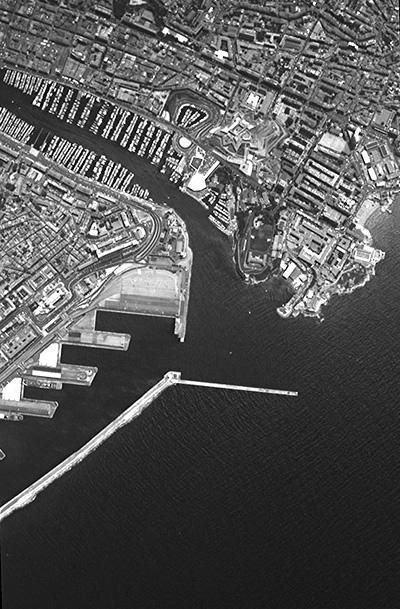
Marseille harbour and sea wall(SPOT 5 simulated Supermode image at 2.5
m)
Other simulated SPOT 5 Supermode 2.5-metre images:
Marignane
Bouc harbour
Lacaune forest
Highway interchange
Supermode applications
Supermode will serve a broad spectrum of SPOT data applications, particularly
forest inventorying, agriculture, surveillance and natural hazard mitigation.
Forest inventorying
Forest mapping is designed to inventory plant species and evaluate timber
resources at national scales. Today, SPOT data are used increasingly
to update maps. SPOT 5 Supermode will provide new information on land
cover and canopy closure, and detect crown thinning, clear-cuts, strips
and vertical stratification. Supermode's enhanced resolution could be
used to add more detail to forest maps.
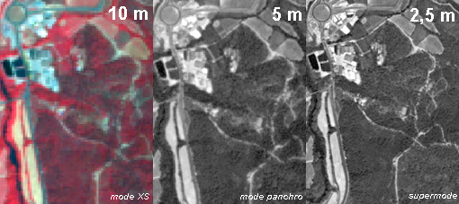
SPOT 5 simulated image - forests in the Hérault
region of France
Agriculture
SPOT panchromatic data are used at the start of agricultural survey
campaigns to identify land cover and measure field acreages. Crops are
identified by analysing multispectral data acquired at different dates.
Supermode data will make it possible to discriminate closely aligned
crops such as orchards and vineyards, which are difficult to identify
in currently available satellite imagery. They will also yield highly
detailed information about crop health and status within individual
parcels.
SPOT 5 simulated image - farmland (near Lavaur, south-west France)
Surveillance and hazard mitigation
SPOT 5 Supermode 2D or stereoscopic data are ideally suited to reconnaissance
and interpretation for mission planning, strategic intelligence, crisis
monitoring, and monitoring of disarmament accords and industrial and
urban sites.
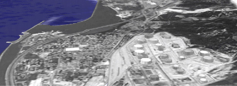
Perspective view of Fos-sur-Mer, France (2.5-metre
Supermode image)