![]()
The SPOT satellites orbit the Earth at an altitude of 822
kilometres at the Equator. To maintain a constant resolution, this orbit is
circular.
To be able to acquire images of any point on the globe, the orbit is near
polar. In other words, because of the Earth's rotation the subsatellite point
follows a regular pattern of ground tracks on the Earth's surface.
The orbit is also phased so that the satellite passes over
the same point every 26 days. The satellite thus repeats the same ground tracks
and the maximum distance between adjacent tracks at the Equator is 108 kilometres.
The combined field of view of the two instruments in twin-vertical configuration
is 117 kilometres, so the entire Earth can be covered in a single 26-day cycle.
Lastly, the orbit is Sun-synchronous so that solar illumination conditions vary as little as possible. The orbital plane forms a constant angle relative to the Sun direction and the satellite passes over any given point at the same local time within two minutes. The Equator crossing time is 10:30 a.m.
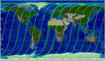
SPOT satellite ground tracks (one day)
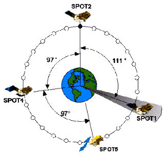
SPOT 5 will join SPOT 1, SPOT 2 and SPOT 4 on the same
orbit. Each satellite is phased relative to the others to optimize repeat
image acquisition and to allow receiving stations and the CMP operations control
centre to track the satellites without introducing additional operational
constraints.
The satellite reaches its final orbital position after a series of manoeuvres.
The orbit emplacement strategy, which allows for the degree of orbit injection
error due to the launch vehicle and for constraints imposed by operations
on the other SPOT satellites, is designed to keep the positioning phase as
short as possible and to conserve propellant for manoeuvres.
The SPOT satellites
![]() Spot satellite ground
tracks (one day) (QuickTime film: 1500 kb)
Spot satellite ground
tracks (one day) (QuickTime film: 1500 kb)