![]()
The VEGETATION 2 instrument is an independent
payload. It is identical to the instrument on SPOT 4, with some enhancements
to critical technologies such as sensors and optical coatings.
With the VEGETATION ground segment, it forms a complete, autonomous, operational
system. It is a follow-on to the first payload operating on SPOT 4 since 1998.
The VEGETATION payload comprises:
- an imaging instrument with four independent cameras,
- an image processing subassembly to generate synchronization signals and format image streams,
- an onboard data handling subassembly to operate and monitor payload devices,
- an onboard recorder able to store 97 minutes of imagery,
- an X-band telemetry subassembly to downlink stored image data,
- an L-band telemetry subassembly to send image data directly to ground stations,
- a unit controlling mechanisms, the calibration lamp and thermal control heaters.
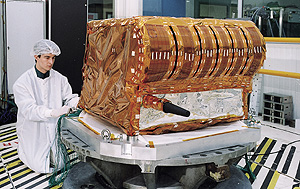
VEGETATION payload on SPOT 5
These subassemblies are mounted on a structure below the HRGs next to the
HRS instrument.
| TECHNICAL DATA | |||
| Mass (kg) | 153.5 | Bits per pixel | 10 Bit |
| Dimensions (m3) | 0.7x1x1 | L-band telemetry rate (Kbps) | 510 |
| Consommation d'énergie (W) |
160 max |
X-band telemetry rate (kbps) |
3400 |
| Transmission frequencies |
|
Lifetime(years) |
> 5 |
|
X-band
|
8153 MHz |
||
|
L-band
|
1704 MHz | Storage capacity(Gbits) | 2.25 |
(click with your mouse on the VEGETATION payload's subsystems for more details)
The imaging instrument has four cameras, one for each spectral band. Each camera observes the full field of view and ensures perfect inter-band registration.
Three of the spectral bands are the same as those on the HRG instruments (B2, B3 and SWIR for observing plant cover and deriving vegetation indexes). The fourth band (B0, 0.43 - 0.47 mm) is unique to the VEGETATION instrument. Ground reflectance of vegetation cover in this band is minimal and atmospheric aerosol scattering is maximum. This band is therefore used to correct measurements in the three other bands for atmospheric effects.
The cameras' very wide field of view (101°) results in a ground swath of 2,250 kilometres. Resolution has been defined to optimize the instrument's mission, yielding a ground pixel size of 1.165 km x 1.165 km. Thanks to its wide imaging swath, VEGETATION covers almost all of the globe's landmasses in a single day. It observes landmasses during the daytime and stops imaging when the satellite passes over the oceans.
The instrument collects light reflected from the Earth's surface and converts the signals into digital radiometric values. Radiation emitted by the target area goes through a 13-lens objective, which has a wide-angle spherical/parabolic lens at the front that converts light signals into a constant illumination in the focal plane, where the detectors are located.
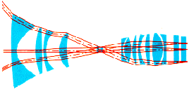 Optical
path of VEGETATION cameras
Optical
path of VEGETATION cameras
The linear arrays sensing in the visible bands are composed of silicon CCD detectors. The short-wave infrared (SWIR) array uses indium gallium arsenide (InGaAs) CCDs.
Each camera has:
- an array of 1,728 individual detectors identical to those in each visible spectral band on SPOT 4 (B0, B2 and B3),
- 10 modules of 300 SWIR detectors (individual detector size: 20 x 30 mm); only the 1,728 detectors in the six central modules are used.
After analogue corrections, data from the four spectral channels are grouped
and multiplexed for digitization and then 10-bit encoded.
Acquired signals are sent to the video electronics unit for digitization and
then to the image processing units, which direct them to the recorder or transmitter.
Image telemetry is:
- read out from the solid-state memory and downlinked when the satellite is
within range of the Kiruna receiving station on the X-band frequency of 8,153
MHz at a data rate of 3.4 Mbps; SPOT 5 and VEGETATION signals are frequency-division-multiplexed
and transmitted by SPOT 5's X-band antenna;
- or downlinked in real time to regional stations on the L-band frequency
of 1,704 MHz at a data rate of 510 kbps; direct transmission uses an L-band
antenna dedicated to VEGETATION.
See images acquired by VEGETATION:
![]() Images
of the globe (SPOT 4)
Images
of the globe (SPOT 4)
Animated
one-year global synthesis (SPOT 4)
First SPOT 5 image (India)
Other SPOT 5 images (Europe,
Ormuz, Mozambique,
Scandinavia)
More about the VEGETATION system at: http://spot-vegetation.com/