![]()
Spectral bands - Resolution - Swath
Spectral bands for Earth observation applications are
selected on the basis of: · spectral response-that is, the specific nature
of signals reflected or emitted across a range of wavelengths-of features
of interest, for example land surfaces, vegetation, deserts, snow, moisture
and urban areas
· atmospheric transparency and transmission stability, which can only be sufficiently
ensured within certain spectral "windows"
The bands on SPOT 5 in the visible and short-wave infrared portions of the
spectrum are identical to those on SPOT 4:
· panchromatic (wide band): 0.49 -0.69 µm
· visible B0: 0.43 to 0.47 µm (for VEGETATION only)
· visible B1: 0.50 to 0.59 µm
· visible B2: 0.61 to 0.68 µm
· visible B3: 0.78 to 0.89 µm
· short-wave infrared (SWIR): 1.58 to 1.75 µm
The new HRS instrument acquires images in the panchromatic band only.
| Spectral band |
HRG
|
VEGETATION
|
HRS
|
| PA 0.49 -0.69 µm |
2.5* ou 5 m
|
-
|
10 m
|
| B0 0.43 - 0.47 µm |
1 km
|
-
|
|
| B1 0.49 - 0.61 µm |
10 m |
- |
-
|
| B2 0.61 - 0.68 µm |
10 m |
1 km |
-
|
| B3 0.78 - 0.89 µm |
10 m |
1 km |
-
|
| SWIR 1.58 - 1.75 µm |
20 m |
1 km |
-
|
| Field of view |
60 km |
2250 km |
120 km
|
* 2.5 metres using SPOT 5's unique new Supermode
sampling concept.
HRG and
HRS swathes
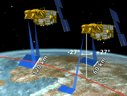
Each HRG instrument has a field of view of 4°, meaning that it can observe
a swath of 60 kilometres on the ground, and can be pointed off-vertical 27°
both ways for oblique viewing. Like on SPOT 4, the two instruments generally
operate independently to observe separate targets, but they can also view
in tandem to cover a 120-kilometre swath in a single pass.
The HRG instruments' oblique viewing capability means that SPOT 5, like its predecessors, can acquire imagery of any point on the globe within less than five days, or even in less than three days at temperate latitudes.
 HRG imaging swath and oblique
viewing capability
HRG imaging swath and oblique
viewing capability
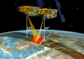
The field of view of each of the HRS instrument's
cameras is 8°, meaning that it observes a swath of 120 kilometres centred
on the satellite ground track. The front camera points 20° ahead of the nadir
and the rear camera 20° behind. The maximum scene length in stereo imaging
mode is thus 600 kilometres.
 HRS field of view
 HRG-HRS imaging sequence: video (1,11
Mb)
HRG-HRS imaging sequence: video (1,11
Mb)
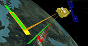
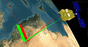
The two instruments view independently (yellow: front HRS camera; ochre: rear
HRS camera; green: HRG 1; red: HRG 2).
 HRG
imaging sequence: video (419 kb)
HRG
imaging sequence: video (419 kb)
HRG1 and HRG2 view in tandem to cover a ground swath of 120 kilometres.
VEGETATION swath
The VEGETATION instrument's wide field of view results in a ground swath of
2,250 kilometres, giving it the ability to cover almost all the globe's land
surfaces every day. Equatorial zones below 30° latitude are covered four days
out of five. Zones above 30° latitude are covered at least twice daily.
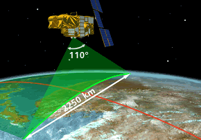 VEGETATION Field of view
7 days of VEGETATION imagery (animation)
The instrument covers almost the entire globe every day, with a field of view resulting in a ground swath of 2,250 kilometres. Equatorial zones below 30° latitude are covered four days out of five. Zones above 30° latitude are covered at least twice daily.