![]()
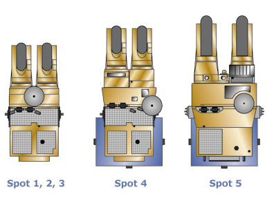
Spot 1,2,3
An Ariane launcher placed the SPOT 1 satellite into
orbit on 22 February 1986. Two days later, SPOT 1's high-resolution visible
and infrared instrument (HRVIR) acquired its first high-quality image, with
a spatial resolution of 10 to 20 metres.
The SPOT 2 satellite was launched on 22 January 1990. Identical to its predecessor, SPOT 2 was the first in the series to carry the DORIS precision positioning instrument.
SPOT 3 followed on 26 September 1993. It also carried the DORIS instrument, plus the American passenger payload POAM II, used to measure atmospheric ozone at the poles.
SPOT 1 and SPOT 2 are still operational.
SPOT 3 failed in 1996, having reached the end of its nominal mission lifetime.
Spot 4
Launched on 24 March 1998, SPOT 4 features significant improvements over its
predecessors, including a longer five-year design lifetime and enhanced imaging
telescope features and recording capabilities. A spectral band in the short-wave-infrared
(SWIR, 1.55-1.75 µm) was added and the panchromatic band (0.49-0.69 µm) was
replaced by the B2 band (0.61-0.68 µm), which acquires images on request at
10-metre or 20-metre resolution.
 |
|
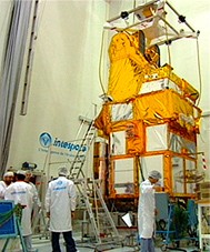
SPOT 4 under test at Intespace
|
SPOT 4 carries the VEGETATION optical payload, which offers a spatial resolution of one kilometre and a wide imaging swath. VEGETATION operates in the same spectral bands as the HRVIR instrument, including the SWIR band, plus an additional blue band (B0, 0.43-0.47 µm). The HRVIR and VEGETATION missions are highly complementary. Both instruments use the same spectral bands and geometric reference system, which means that images from the two register very accurately.
For more information on SPOT 4
go to
http://Spot4.cnes.fr
Spot 5
The credibility of an Earth observation system such as SPOT depends
on continuity of service and ever-improving image quality. SPOT 5 was designed
with this dual objective in mind.
While retaining the main characteristics that have earned
SPOT a worldwide reputation for its acquisition capability, with the same
orbit, spectral bands and imaging swath of 60 kilometres either side of the
ground track, the new SPOT 5 satellite offers improved ground resolutions
of 10 metres in multispectral mode and 2.5 to 5 metres in panchromatic and
infrared mode.
Higher 2.5-metre resolution is achieved using an innovative sampling concept
called Supermode.
SPOT 5 also features a new HRS imaging instrument (High
Resolution Stereoscopic) operating in panchromatic mode and able to point
forward and aft of the satellite. In a single pass, the forward-pointing camera
acquires images of the ground, then the rearward-pointing camera covers the
same strip 90 seconds later. HRS is thus able to acquire stereopair images
almost simultaneously to map relief, produce digital elevation models (DEMs)
of wide areas and generate orthorectified products of a quality unequalled
on the market today. The HRS instrument can acquire up to 126,000 square kilometres
of data every day, thus providing a fast turnaround for users.
SPOT 5 also carries a VEGETATION 2 instrument identical to that on SPOT 4.
![]() Spot
satellite key figure
Spot
satellite key figure
Spot
satellites,timeline and design lifetime