![]()
Monitoring change
Urban development is one of the key issues facing land-use
planning departments today. Monitoring the spread of urbanization concerns
regions, groups of urban communities or even entire countries, and may sometimes
span international borders. Regional and local development programmes need
geographic information to give decision-makers a broad picture that reaches
across all sectors. Such programmes have to ensure that land-use provisions
are spatially coherent and take environmental issues fully into account.
Collecting uniform and current geographic data for planning purposes is not
always an easy task. Tools for tracking built-up areas, especially in peri-urban
zones, require map coverage of vast areas that is both accurate-to locate
buildings-and uniform.

Land-use planning departments rely on geographic data updated on a yearly basis covering urban conurbations at a scale of 1:10 000. SPOT 5's improved resolution and wide-area coverage lets urban planners:
- Produce land-use maps with CORINE land cover classes
- Go from level 3 to level 4 or 5 by using 10-metre or 5-metre colour imagery
- Identify land-use patterns in specific urban zones, industrial and trading estates, and residential areas
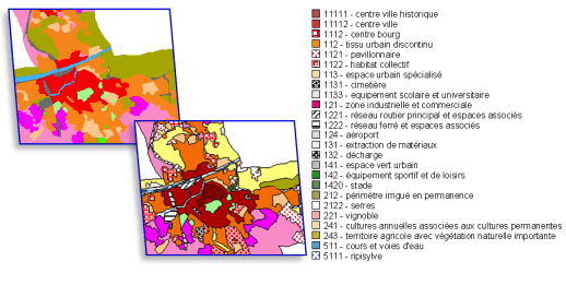
![]() Shape
and distribution criteria can be applied to built-up areas and vegetation
to classify urban areas as:
Shape
and distribution criteria can be applied to built-up areas and vegetation
to classify urban areas as:
- urban historic centre
- urban extra-muros
- urban
- detached housing
- apartments
- specific urban areas

To promote sustainable urban development and enhance quality
of life, urban planning departments are focusing their attention on vegetation
in urban and peri-urban zones-parks and green spaces, hedgerows and wooded
areas bordering lakes, rivers and canals-in order to zone and protect greenbelt
areas.
SPOT 5's improved resolution and spectral sensing capability make it possible
to:
- Locate public and private green spaces
- Populate census parcel maps in urban databases (at 1:10 000)
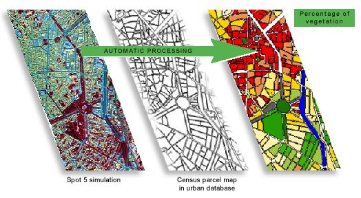
![]() SPOT
5 2.5-metre colour imagery enables automatic calculation of indicators showing
the area covered by vegetation inside each census parcel of the urban database
(at a scale of 1:10 000).
SPOT
5 2.5-metre colour imagery enables automatic calculation of indicators showing
the area covered by vegetation inside each census parcel of the urban database
(at a scale of 1:10 000).

Cities grow by spreading outwards or through a process of densification. Spatial distribution of housing and unoccupied land is the kind of information SPOT 5 imagery can highlight for urban land-use planning.
- SPOT 5 imagery is ideal for characterizing urban growth
|
The advantages of SPOT 5 for urban mapping at 1:10 000 HRG instrument (High Resolution Geometric)
|
References
- SPOT 5 Preparatory Programme - Evaluation of the benefits of SPOT 5 data for mapping urban land use - CERTU.
- SPOT 5 Preparatory Programme - Benefits of very-high-resolution SPOT 5 data for managing urban databases - Scot.