![]()
 Delivering
current geographic information:
Delivering
current geographic information:
Whether sizing new networks or densifying existing ones, telecommunications network planners need up-to-date coverages to build radio propagation models. These digital maps provide essential geographic information about terrain, building heights, land use and linear features. The recent growth of wireless telephone networks is driving demand in the telecoms market, which today is one of the biggest consumers of this kind of geographic information. Customers are looking to obtain more regularly updated information at increasingly precise scales.

Sizing and deployment of wireless telephone networks demand various kinds of information. Network planners mostly use satellite imagemaps, which depict land use and land cover features in urban areas (clutter maps), and digital terrain models (DTMs) or digital elevation models (DEMs) overlaid with communications infrastructures. In recent years, Earth observation data have started catering for these requirements. Thanks to their stereoviewing capacity and their ability to acquire coverages of most of the worlds cities in a single image, the SPOT satellites have built up a large archive of urban imagery that is used to develop standardized products. These products offer a resolution of 10 or 20 metres, making it possible to distinguish more than 10 urban land-use classes.

What mobile phone network planners most need today is a more detailed picture of land use, particularly in dense urban areas. To meet this demand, SPOT 5 will offer products with improved resolution and information content closely tailored to the requirements of operators and equipment manufacturers.
Determining building heights
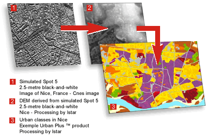
By digitizing building outlines on two SPOT 5 2.5-metre black-and-white scenes
acquired from different viewing angles, and by analysing the differences between
the two, we can determine the height of objects on the ground using photogrammetry
techniques. This information, combined with a DTM showing terrain elevation
above sea level, reveals extra detail for determining building heights. Such
products offer a z-accuracy of around 2.5 metres.
Enhancing land-use information
To obtain better land-use information for telecommunications network planning,
we have to define building height and building density classes and extract
mean height and density values for each class. A possible method of achieving
this would be to add an extra step to the standard process for producing satellite
imagemaps, DEMs and land-use maps. This step would use automatic or semi-automatic
classification of the DEM containing the elevation of each point to classify
groups of buildings according to their height and density, and thus obtain
a more detailed nomenclature.
| Combined advantages of SPOT 5 HRG and HRS
data
HRG instrument (High Resolution Geometric) Capable of covering an entire city and its suburbs in a single scene.
HRS instrument (High Resolution Stereoscopic) Designed specially to acquire wide-area DEMs.
|
References
- SPOT 5 Preparatory Programme: using SPOT 5 VHR data to generate geographic databases for mobile phone network planning Istar
- SPOT 5 Preparatory Programme:Using SPOT 5 imagery
to develop databases for telecommunications frequency planning SPOT 5
International Conference, 14-15 June 2001 Geoimage
Published by the CNES SPOT 5 Project Office - 18 avenue Edouard Belin 31401 Toulouse cedex France http:/www.cnes.fr
SPOT 5 data distributed by Spot Image - http:/www.spotimage.com Production coordinated by Scot