![]()
Meeting multiple needs
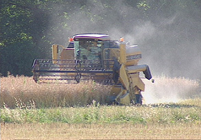
The social, economic and environmental impacts of farming are of strategic importance for the vast majority of the world's nations today. As a result, crop mapping and monitoring are finding applications in such areas as inventorying annual broadacre crops and perennial fruit crops, forecasting crop yields for more effective stock management and food security, managing cultural practices within individual field parcels using precision agriculture techniques, and checking and monitoring farming subsidies within a regulatory framework.

Mapping and monitoring pastures:
In the Zorn valley and along the publicly owned stretch
of the Ill river in Alsace, north-east France, SPOT 5 data have been evaluated
to determine their usefulness in applying and monitoring agro-environmental
measures designed to sustain and encourage a return to livestock farming on
natural pastures.
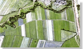
![]() Example
of cadastral map draped over 2.5-metre colour data to generate field survey
documents at 1:5 000. Field survey documents must provide information such
as parcel registration numbers and cadastral boundaries for administrative
identification purposes.
Example
of cadastral map draped over 2.5-metre colour data to generate field survey
documents at 1:5 000. Field survey documents must provide information such
as parcel registration numbers and cadastral boundaries for administrative
identification purposes.
SPOT 5 as an alternative or
complement to aerial photography for field survey documents
Colour data at resolutions of 2.5 metres or 5 metres enable production of
field survey documents at 1:5 000 and 1:2 500 with comparable results to aerial
photography. And besides their excellent geometric quality, SPOT 5 data do
not call for complex mosaicking and brightness matching.
Identifying and monitoring pastures
SPOT 5 data enable better identification of pastures and can discriminate
different types of grassland. SPOT 5 2.5-metre black-and-white imagery also
highlights trees and hedgerows bordering fields and water courses, and makes
it easier to pick out small parcels under crop within pasture areas.
![]() Automatic
classification of 2.5-metre colour data of pasture areas.
Automatic
classification of 2.5-metre colour data of pasture areas.
Data at scales up to 1:5 000 make it easier to map these sensitive areas,
even where the landscape is made up of scattered farmland parcels.
Managing and protecting oilseed
crops:
The advantages of 2.5-metre black-and-white data were tested on a project
called Olisig initiated by ONIOL, France's national agency for growers of
oilseed, high-protein and textile crops. This project aimed to manage olive
growers' subsidy claims.
 Olive trees
are currently counted automatically from one-metre-resolution aerial photographs,
then counts are validated by photo-interpreters.
Olive trees
are currently counted automatically from one-metre-resolution aerial photographs,
then counts are validated by photo-interpreters.
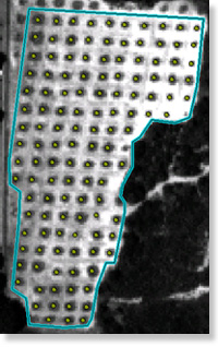
![]() Result
of current counting method using aerial photographs. Zooming 2.5-metre black-and-white
data to 1.25 metres and enhancing them by deconvolution and high-pass filtering
yielded very good results with the same counting method (less than two per
cent error with respect to reference values).
Result
of current counting method using aerial photographs. Zooming 2.5-metre black-and-white
data to 1.25 metres and enhancing them by deconvolution and high-pass filtering
yielded very good results with the same counting method (less than two per
cent error with respect to reference values).
![]() SPOT
5 imagery enables the same kind of automatic counting as with photo-interpretation
and accuracy is excellent.
SPOT
5 imagery enables the same kind of automatic counting as with photo-interpretation
and accuracy is excellent.
| Errors with respect to reference, in per cent (1-metre aerial photo) | |
| Zoomed SPOT 5 image + high-pass filter | 3,9 |
| Zoomed SPOT 5 image + deconvolution | 7,1 |
| Zoomed SPOT 5 image + deconvolution + high-pass filter | 1,8 |
| Zoomed SPOT 5 image + deconvolution + high-pass filter | 3, 3 |
Checking agricultural subsidy
claims:
This operational activity involves comparing farmers' claim forms against
crop acreage and land usage data derived from satellite images. The method
is based on merging information provided by farmers with satellite data and
draping it over a cadastral basemap. Analysts then determine whether to send
out field inspectors from ONIC, the French Ministry of Agriculture's national
cereals agency.
Comparison of SPOT 4 20-metre XS scene and
SPOT 5 10-metre colour and 2.5-metre black-and-white scenes.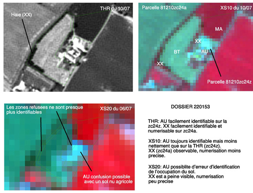
![]() SPOT
5 improves crop identification
SPOT
5 improves crop identification
Colour images with a spatial resolution of 10 metres enable very accurate
crop identification.
SPOT 5 improves boundary detection
Lanes, paths, hedgerows, trees, houses and other non-farmland features are
easy to identify and digitize on 2.5-metre black-and-white images.
The rich thematic content and very high resolution of SPOT 5 imagery facilitate data processing and allow faster and more reliable analysis.
|
SPOT 5 - sustaining continuity and innovation in agriculture Operating in tandem with the VEGETATION instrument to monitor crop status HRG instrument (High Resolution Geometric) Finer spatial resolution and optimized spectral bands
High revisit rate for monitoring crop growth
stages |
References
SPOT 5 Preparatory Programme:
- Evaluation of simulated SPOT 5 data for applying and monitoring agro-environmental measures - Sertit.
- Development of methods for counting olive trees using simulated SPOT 5 data- CS SI - Scot.
- Advantages of SPOT 5 data for checking farmers' subsidy claims using remote sensing data - Scot.