![]()
Meeting vital mapping needs
Traditional maps cover no more than 44 per cent of Earth's landmasses, so the need for basemaps is huge indeed. What is more, nations now investing increasingly in digital geographic information want to update their databases quickly. SPOT 5 will meet mapping requirements at scales of 1:50 000 up to 1:25 000-something that has proved hard to achieve with first-generation satellite data.

SPOT 5, particularly its 2.5-metre black-and-white acquisition mode, offers
the ability to map at new scales for a broad range of applications. SPOT 5's
two key assets are:
- Accurate and detailed observation of terrain features
- Coverage of vast territories.
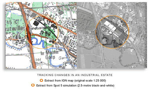
![]() 2.5-metre
black-and-white data from SPOT 5 are well suited to generating or updating
medium-scale databases (such as IGN's BD CARTO®) of regions for which accurate
maps are available.
2.5-metre
black-and-white data from SPOT 5 are well suited to generating or updating
medium-scale databases (such as IGN's BD CARTO®) of regions for which accurate
maps are available.
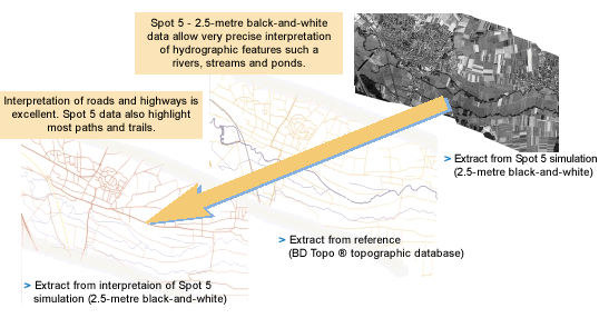
![]() This
example shows the level of detail achievable using SPOT 5 black-and-white
data with 2.5-metre resolution.
This
example shows the level of detail achievable using SPOT 5 black-and-white
data with 2.5-metre resolution.
SPOT 5 data even exceed operational requirements for updating map databases
of this type of landscape.
An unrivalled tool for producing and updating topographic maps in developing
countries.
In developing countries where maps are often out of date and vast areas need
to be covered, 2.5-metre black-and-white data from SPOT 5 are ideal for generating
high-quality map products at scales of 1:50 000 up to 1:25 000.

Defence simulation and training
Simulation and training applications call for accurate and realistic
3D databases, which can be generated from SPOT 5 stereopair imagery.
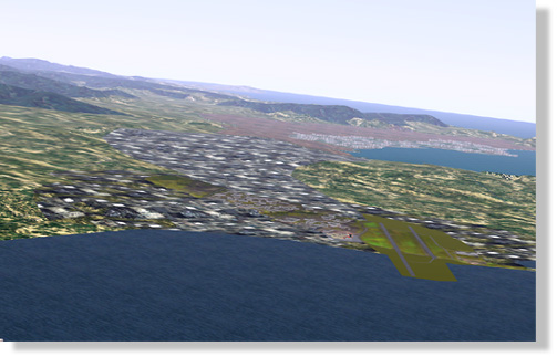
![]() 3D
databases for simulation applications can be generated with SPOT 5 2.5-metre
black-and-white data used to derive:
3D
databases for simulation applications can be generated with SPOT 5 2.5-metre
black-and-white data used to derive:
- digital elevation models (DEMs)
- orthoimages
- man-made features extracted by photogrammetry.
Trials conducted with simulated SPOT 5 data show that extraction of man-made
and planimetric features using photogrammetric techniques is of great value
for rehearsing missions, where features need to be represented in three dimensions
as realistically as possible.
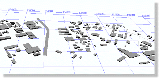
![]() 3D
superstructures extracted by photogrammetry. Elevation accuracy is sufficient
to meet application needs.
3D
superstructures extracted by photogrammetry. Elevation accuracy is sufficient
to meet application needs.
|
References
SPOT 5 Preparatory Programme
- Study of the use of SPOT 5 Supermode data for generating 3D simulation and training databases - Thales.
- Evaluation of the use of SPOT 5 Supermode data for updating map databases - IGN.